Houston City Council Unanimously Approves Establishing A TIRZ For Montrose

After many months of community meetings, stakeholder discussions and volunteer-based research by residents, the Houston City Council unanimously voted on Wednesday, December 9th to create a Tax Increment Reinvestment Zone, commonly known as TIRZ, for the Montrose area. The funds the TIRZ will generate will help Montrose repair and enhance its currently failing infrastructure.

This is great news for Montrose to address the "critical needs" we have related to infrastructure. At many of our general meetings, we've talked about how our streets are currently failing. This Montrose TIRZ will facilitate completion of infrastructure projects much more quickly than the City's Capital Improvement Plan and, ultimately, this Montrose TIRZ will lead to more City funds being freed up for the CIP projects to be prioritized/completed elsewhere. This is a net gain.

We are excited that the goals of the Montrose TIRZ include projects around:

  1. Infrastructure improvements
  2. Pedestrian-friendly and cyclist-friendly environments through the reconstruction of streets, infrastructure and sidewalks, with lighting and streetscape amenities
  3. Facilitation of completion of transit corridors
  4. Economic development and growth
  5. Reinforcement of pedestrian-attractive retail developments and mixed-use developments along the major corridors
  6. Parks and related amenities
  7. Workforce housing

Winlow Place has been involved significantly throughout this year-long process, and along the way it became very clear that Montrose streets don't just serve Montrose – our transit corridors are the day-to-day work horses for commuter traffic to get people to jobs, schools and homes. This TIRZ is a much-needed practical solution for our needs – today andtomorrow – and we are so pleased that it passed unanimously.

Many thanks to you all for the conversations throughout the past year.

– by Caroline Garry

The City Needs Your Input for the Design of the Reconstruction of Dunlavy

Be Sure to Submit Your Comments to the City by December 15, 2015 Regarding the Reconstruction of Dunlavy

On November 18th, the City Public Works and Engineering Department and the Planning Department provided a joint-presentation on new bicycle facilities on Dunlavy between Allen Parkway and Richmond; and the scheduled Dunlavy reconstruction between Allen Parkway and West Gray and between Richmond Alabama. Their reconstruction efforts will include new roadway, storm drainage, sewer infrastructure and new bicycle facilities. The segment of Dunlalvy adjacent to WinlowPlace itself is not currently under design, but they are looking for our input as they consider the entirety of Dunlavy and the neighborhood's needs. This is the "Middle Segment" between Peden and West Main.

If you missed the meeting, please review the presentation, linked here, yourself. They are specifically looking for comments regarding the configuration of bike lanes, pedestrian amenities and on-street parking. Anything else is fine, too, but pay particular mind to those items. It is likely that, when funded, the Winlow Place segment of Dunlavy would be modeled more similarly to the Southsegment, which in the presentation is Richmond to West Alabama.

The main thing to note is that they need your comments and input by DECEMBER 15th.
This handout has those details, but you can also just email comments to pweplanning@houstontx.gov.


unnamed.jpg

For the North Segment, from Allen Parkway to Peden, they plan to:

  • Reduce number of lanes to accommodate a continuous turn lane
  • Improve signals and turn lanes at intersections 
  • Replace storm and water system 
  • Improve pedestrian realm 
  • Improve bike facilities

Possible configuration of North Segment is shown in the illustration to the right.


unnamed-2.jpg

For the South Segment, West Main to Richmond, they plan to:

  • Create dedicated parking area
  • Improve signals and turn lanes at Richmond
  • Replace storm, water and sewer systems as necessary
  • Improve pedestrian realm 
  • Add bike facilities

Possible configuration of South segment, which is likely the one that might be most like what we'll eventually have, is shown in the illustration to the right.


Note that this is unrelated to the Major Thoroughfare and Freeway Plan Proposed Amendments that we fought for with the City. Those were specifically related to leaving Dunlavy with its current 60-foot right of way (so that the City would not "take" an additional 70 feet), as well as reclassifying Dunlavy from a 4-lane Major Collector to a 2-lane Major Collector. With the new classification, which we won, Public Works & Engineering is still able to "design" new street configuration within that given (60-foot) right-of-way. This may include, it sounds like, new bike lanes which after hearing public input at many meetings, might be a great thing pending the exact design.

Again, the main thing to note is that they need your comments and input by December 15, 2015.
Read the presentation, linked here, yourself. Note that This handout has information for how to submit feedback, but you can also just email comments to pweplanning@houstontx.gov.

– by Caroline Garry

Re-opening of Buffalo Bayou Park

Buffalo Bayou Park has officially re-opened, and in perfect timing with this fall weather! The park has undergone extensive renovations over the past four years, and you can look forward to some amazing updated amenities. These new features include four pedestrian bridges, visitor's centers, a skate park, a nature/play area with rock climbing, an extensive dog park, updated hike/bike trails, and more!

Buffalo Bayou Park is a major connector in the vision to create and connect 300 miles of continuous hike/bike trains throughout Houston. With the renovations to the park completed, work will begin this fall along White Oak Bayou to implement trails between Stude Park and the Heights hike/bike trail – that work is expected to be completed within a year.

Guest Post: My Tax Dollars at Work

Winlow Place was delighted to be offered this article as a guest post from Sherry Weesner, a very active member of the Montrose community. Her civic club discusses many of the same issues we do, so she is keenly aware of the types of questions our residents often ask. Her post is below – please enjoy!


My Tax Dollars at Work

I know we all complain a lot about where our taxes go. Well, I've discovered a place where you can see how your City of Houston property taxes are spent.

The City's approximately $2 billion General Fund is its largest fund and supports the majority of the basic services of the City, such as police and fire protection, health and human services, and garbage collection. The largest sources of revenue for the General Fund are property and sales taxes, which together make up approximately 70% of the General Fund.

The current property tax rate for the City of Houston is 63.108 cents per $100 of assessed valuation. The sales tax rate for the City is 1 cent, METRO's is 1 cent and the State of Texas' tax rate is 6.25 cents per dollar for taxable items purchased. Obviously, most of the sales tax you pay ends up in the State's budget.

We also pay the Drainage Utility Charge (ReBuild Houston) – which shows up on your water bill. The fee is either 3.2 or 2.6 cents per year per square feet of impervious surface depending on the type of road you live on (curb and gutter or open ditch). This fee pays for street and drainage improvements within the city. The city has approximately $1.7 billion in road and drainage infrastructure debt and pays nearly $150 million per year in interest on that debt. 11.8 cents of every $100 of property value collected is currently going to pay off the debt incurred on previous street and drainage projects. As this debt is repaid the funds will be used for street and drainage improvements around the city.

To review the taxes you pay to other entities like HISD visit the Harris County Appraisal District website.

The City has created a website to show us how our property taxes are spent. The My Tax Dollars at Work website on the City of Houston's webpage allows each of us to analyze how our Property Taxes are spent. The page has not been updated to the most recently adopted budget but I expect that will happen soon. The current budget is similar to the budgets approved over that last several years.

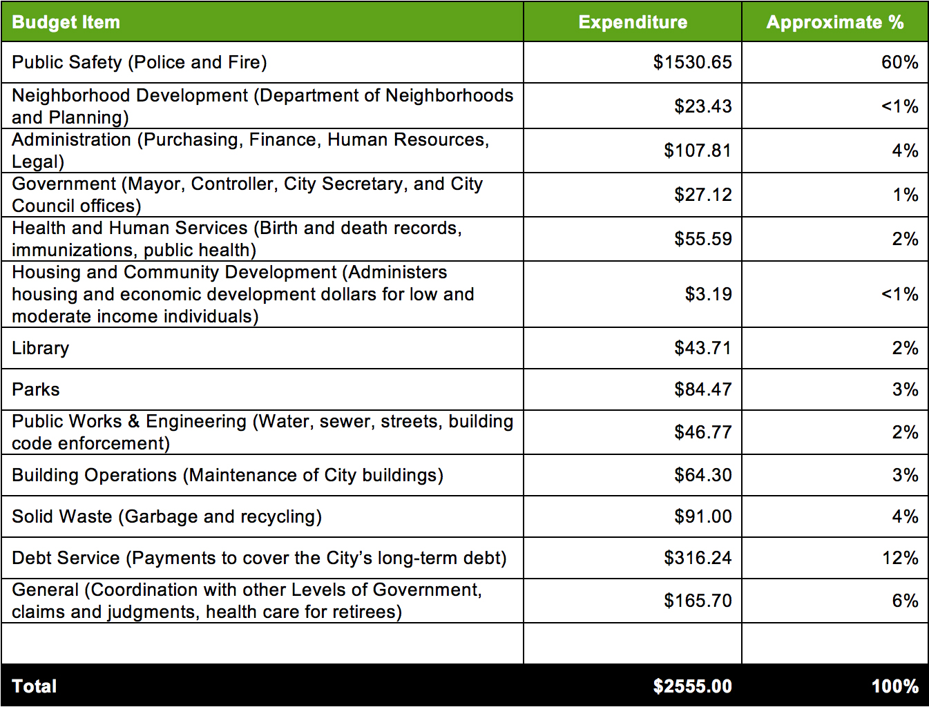
I utilized the website to analyze where the taxes are spent for a typical property in our area. For this example, I evaluated a property with a $500,000 appraised value with a homestead exemption.


Below is a detailed breakout of how the annual property taxes are spent:

– Guest post by Sherry Weesner

Share Your Opinion on West Alabama

Last Thursday evening over 200 residents/voters attended a meeting facilitated by Council Member Cohen and the City's Public Works and Engineering Department regarding the upcoming reconstruction of West Alabama. As you know, there are major questions regarding the function of that street such as the reversible lane.

What we learned:

West Alabama is being split into four segments in order to complete this work. The segment that is adjacent to Winlow Place is the 3rd segment, outlined below:

  1. Weslayan Street to Buffalo Speedway: Work to be completed by the City of Houston, construction estimated FY2016
  2. Buffalo Speedway to Shepherd Drive: Work to be completed by the Upper Kirby TIRZ, design not started
  3. Shepherd Drive to SPUR 527: Work to be completed by the City of Houston, construction estimated FY2018
  4. SPUR 527 to Chenevert Street: Midtown TIRZ, design not started

Senior Assistant Director Carol Haddock gave a presentation outlining the current state audit vs. future state considerations and also confirmed that the street will no longer have the reversible lane. Other major points are that the street may be composed of two travel lanes (one in either direction, East to West), with a turn lane in the center – and that the final, comprehensive design will accommodate cyclists (via options presented below) as well as pedestrians. The link to Carol's full presentation can be found here, but please continue reading as the design needs your input, particularly with regards to bicycle lanes/pedestrian amenities. 

The City is currently looking for our input by August 30, 2015:

Two options were presented regarding bike path and intersection configuration options, and the Department is requesting public input by August 30th on those and all other aspects of the reconstruction. Some attendees had suggestions that may be, say, a hybrid of Options 1 and 2. Be sure to clarify any preferences/suggestions in your comments as you submit them.

How to send comments to the City:

Please contact pweplanning@houstontx.gov or 832.395.2500 with your suggestions.

– by Caroline Garry